At St. Andrews State Park, sunrise and sunset do not belong to the same shoreline. That is what makes this park so interesting. You are not looking at one beach with one personality. You are looking at a coastal landscape where the Gulf of Mexico, St. Andrew Bay, and Grand Lagoon all shape the light in different ways. The official park management plan puts the shoreline total at about 68,800 feet, or roughly 13 miles, with about 4.6 miles of Gulf beach across the park footprint.[a] So the real question is not “Where is the best view?” It is which kind of light you want to stand inside.
🌅 The Most Important Detail First: day-use entry is 8 a.m. until sundown.[b] That means true sunrise inside the mainland park is usually an overnight-guest advantage, not a typical day-visitor experience. For standard visitors, St. Andrews is naturally stronger at sunset. For campers and other overnight guests, the park opens up a second identity at first light.
How Light Works At This Park
Florida State Parks describes St. Andrews State Park as a place where five distinct ecological landscapes meet.[c] That matters for sunrise and sunset more than most travel writeups admit. The official brochure also frames the mainland experience as a peninsula with more than 1.5 miles of white-sand beaches.[d] Put those two facts together and the park starts to make sense: open Gulf edges give you the clean horizon, bay and pass edges give you layered water and channel detail, and interior marsh and lake overlooks hold softer low-angle light after the horizon show is gone.
The park also has built-in viewing advantages that are easy to miss on a quick visit. The management plan lists three dune crossover boardwalks, a dedicated beach overlook, a Lagoon Use Area, two marsh and lake overlook systems, and a long Gulf pier on the mainland parcel.[a] In other words, the best light is not random here. The park has specific structures and shorelines that shape exactly how the sky is seen.
| Spot | Best For | What Makes It Strong | Access Reality |
|---|---|---|---|
| Gulf Beach Overlook And Dune Crossovers | Classic sunset | Open horizon, elevated look, dune foreground, wide sky | Excellent for standard day visitors |
| West jetty And Jetty Beach | Dramatic sunset | Rock texture, moving water, pass foreground, layered color | One of the strongest late-day choices |
| Gulf Pier | Elevated sunset and afterglow | More height, longer sightline, less beach clutter | Best when you want distance and structure |
| Pass-Facing Shoreline Near The East Jetty | True sunrise | First light hits the pass and channel cleanly | Mostly an overnight-access advantage |
| Buttonbush Marsh Overlook | Morning light after the gate opens | Low-angle glow on marsh texture and grasses | Great for nature-focused mornings |
| Gator Lake And Heron Pond Edge | Soft early light | Sheltered water, calmer reflections, filtered color | Better for subtle scenes than for a full horizon |
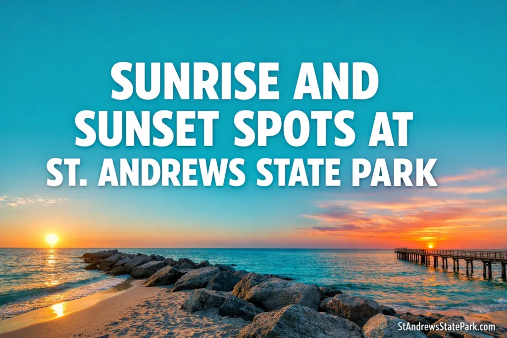
The Sunset Spots That Deliver The Strongest Finish
Gulf Beach Overlook And Dune Crossovers
This is the most complete sunset experience on the mainland. The reason is simple: space. The overlook gives you a cleaner read on the sky, and the dune crossovers let you step into the broad Gulf edge without losing the shape of the landscape. On paper, that sounds ordinary. In person, it is where the park feels most like a vast open stage. The management plan even calls out the mainland’s 44 acres of beach dune, which explains why the foreground here feels richer than a flat parking-lot beach access point.[a]
If you want the sky to do most of the work, start here. Open-water color reads best from this stretch because the scene is not crowded by inland trees, marina structures, or tighter shorelines. It is the cleanest place to watch the orange band soften into rose, then into a pale steel blue that seems to hang over the water a little longer than expected.
West Jetty And Jetty Beach
If the Gulf overlook is the clean classic, the west jetty is the more dramatic version. This is where sunset picks up foreground muscle. Rock lines, moving current, and the shape of the pass give the light something to bounce off and something to silhouette. That matters. A beautiful sky is one thing. A beautiful sky with structure underneath it is another.
The official plan notes that the park is a popular access point for diving around both jetties and that Jetty Beach is already a favored shoreline zone.[a] That popularity makes sense visually. The water here rarely looks flat in the same way the open beach can. Even on quieter evenings, there is usually enough texture in the surface to catch copper, bronze, and deep blue in separate layers.
Gulf Pier
The Gulf Pier is where sunset becomes more technical. Elevation changes the whole read of the evening. You are no longer just watching color spread across the beach. You are looking outward, with more air between you and the shoreline. The park plan says the pier extends more than 400 feet into the Gulf.[a] That extra reach gives the horizon a cleaner finish and reduces the feeling that you are peeking at sunset from behind the beach.
This is also one of the strongest places for the minutes after sunset. Some spots are only about the final drop of the sun. The pier is better than that. It holds the afterglow well, especially when the sky clears near the horizon but keeps enough higher cloud to catch the last warm light.
🌇 Why Sunset Feels So Strong Here: the mainland park gives you built access to open Gulf horizon, including the overlook, boardwalks, jetty area, and the long pier. That is a rare combination inside one park road loop.
Where Sunrise Really Works
Pass-Facing Shoreline Near The East Jetty
For a true sunrise inside St. Andrews State Park, the best logic is the pass-facing water near the east jetty and the channel edge. The park plan references access and activity around both jetties and notes a designated landing area just inside the east jetty along the channel.[a] That matters because first light tends to read best where the view opens toward the pass rather than where the shoreline turns you back toward interior water.
This is the part many generic guides leave out: sunrise here is not mainly about finding a prettier bench. It is about having legal early access. The park has a large campground, with 176 sites and 4 bathhouses along Grand Lagoon, so overnight guests are the ones most likely to experience that first clean beam of light from inside the park boundaries.[a]
Buttonbush Marsh Overlook
If you arrive after the gate opens, the smartest early-light move is often Buttonbush Marsh Overlook, not the open beach. Why? Because marsh light lingers. Low sun catches grasses, edges, and still pockets of water in a softer way than the fully exposed Gulf edge. The base map in the management plan specifically identifies the Buttonbush Marsh Overlook, which gives this spot more value than a random roadside pull-off feeling.[a]
This is not the place for the big orange disc breaking the horizon. It is better than that for some visitors. It gives you texture, depth, and a quieter color story. On mornings when the beach light already feels flatter, the marsh can still look alive.
Gator Lake And Heron Pond Edge
The inland water scenes around Gator Lake and Heron Pond are a different kind of morning asset. The park road system and mapped trail network connect these areas to overlooks and short interpretive walks on the mainland parcel.[a] That makes them dependable early-morning light zones even when you missed literal sunrise.
I like these quieter inland edges because they show another side of the park. St. Andrews State Park is easy to picture as only white sand and open surf. Early light around the lake and pond proves otherwise. It shows why the park’s ecology matters to the viewing experience, not just the recreation brochure.
What Changes Through The Year
The sun’s position does not stay fixed. It slides along the horizon through the year, which means the strongest sunrise and sunset compositions slide with it.[e] In the warmer part of the year, first light arrives earlier and swings farther north, which makes strict sunrise access even harder for day visitors. In cooler months, the lower sun stretches shadows longer and often makes the park’s dune, jetty, and marsh textures feel more sculpted.
- Cooler Months: lower light angle, longer shadows, softer gold on dunes and boardwalks.
- Late Spring And Summer: earlier sunrise, stronger blue water, and later evening color on the Gulf side.
- Shoulder Seasons: the most balanced time for both marsh detail and open-horizon color.
🧭 The Best Way To Read This Park: think of it as a three-sided light field—open Gulf for the broad sunset, pass and bay edges for true first light, and marsh and lake overlooks for softer low-angle color after the horizon moment has passed.
Questions People Often Ask
Is St. Andrews State Park Better For Sunrise Or Sunset?
Can Day Visitors Watch True Sunrise Inside The Park?
What Is The Best Mainland Sunset Spot?
Does The Gulf Pier Change The Sunset Experience?
Which Areas Work Best For Soft Morning Color Instead Of A Big Horizon?
Footnotes And Official References
- [a] Florida Department of Environmental Protection — St. Andrews State Park Approved Plan (2016): used for shoreline totals, Gulf beach length, dune acreage, named use areas, pier length, campsites, carrying capacity, and mainland/Shell Island land-use details. (Reliable because it is the park’s official state management plan.)
- [b] Florida State Parks — Hours & Fees: used for current operating hours and day-use access timing. (Reliable because it is the official park-operator page for current visitor information.)
- [c] Florida State Parks — St. Andrews State Park: used for the official ecological overview of the park. (Reliable because it is the official park page maintained by the state park system.)
- [d] Florida State Parks — St. Andrews State Park Brochure And Map: used for peninsula layout and the mainland beach-length framing. (Reliable because it is an official park brochure published by the state park system.)
- [e] NOAA Global Monitoring Laboratory — Solar Calculation Details: used for the seasonal sunrise/sunset movement and solar-position framework. (Reliable because NOAA is a U.S. government scientific authority for solar calculations.)